
Doggin’ The Hand of Man
ONE OF THE REASONS OFTEN GIVEN FOR BANNING DOGS FROM TRAILS IS THAT THEY SOMEHOW SPOIL THE BEAUTY OF THE WILDERNESS. WHILE WE WILL ALWAYS CHERISH THOSE JOURNEYS INTO AREAS SEEMINGLY TOUCHED BY NOTHING OTHER THAN THE HAND OF NATURE THERE ARE ALSO MANY TIMES THAT THE INTEREST OF A HIKE IS HEIGHTENED BY THE INTRUSION OF MAN - TO A FIRETOWER OR BRIDGE OR HISTORIC RUIN.
Multnomah Falls Loop #2 OR
Columbia River Gorge National Scenic Area, Troutdale OR. Created by a cataclysmic blast of glacial lake water 15,000 years ago, the Columbia River flows through one of the few east-west canyons in the world. Some 77 waterfalls tumble off ridges and sheer walls that soar 2,000 feet above the river. Included in this hydrospectacular bounty is the larg- est concentration of high waterfalls in North America. No wonder the Columbia River Gorge between Oregon and Washington was designated America’s first National Scenic Area.
Multnomah Falls is the emperor of Columbia Gorge waterfalls with a year- round plunge of 620 feet in two sheer drops. This is the biggest natural attraction in the Pacific Northwest with two million visitors each year. And right there in the middle of every photo is a bridge.
While building the Columbia River Highway engineer and landscape architect Samuel Lancaster often mused about the possibility of building a footbridge across the lower cascade. When highway benefactor Simon Benson was visiting the site Lancaster mentioned his vision for a bridge 105 feet in the air. The lumber baron reached for his checkbook and Oregon soon had its most-photographed piece of architecture. Bridge designer Karl Billner gave the 52-foot concrete bridge a 45-foot parabolic arch span with a balustrade railing simpatico to the main bridges on the Historic Columbia River Highway.
Most of the two million visitors won’t venture past the overlook at Multnomah Falls Lodge. Many will go to the historic Benson Bridge across the middle and far fewer will even follow the switchbacking paved path for 1.2 miles to the very top of the iconic cataract.
But your trail dog will want more. Continue on the Larch Mountain Trail (#441) into the lush old growth forest, passing more waterfalls. In less than one mile, link into the Wahkeena Trail (#420) for the walk back down. Fairy Falls, a lovely fan-style waterfall, highlights this leg of the canine hike. Near the bottom of the 4.8-mile loop the natural surface trail passes hard by the 242-foot Wahkeena Falls that squeezes through a moss-covered volcanic cliff. That will give your dog over 1,000 feet of waterfalls for only a few hours purchase.
Whitewater Canyon Catwalk NM
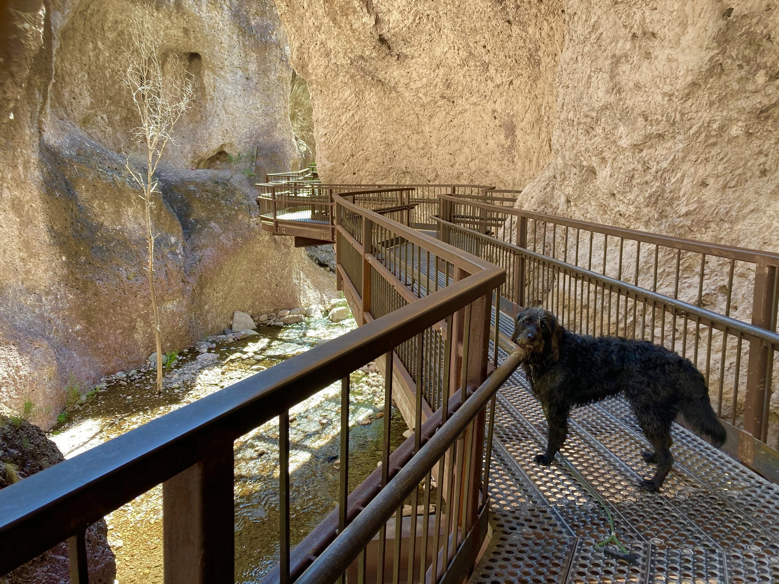
Gila National Forest, Glenwood NM. New Mexico harbors some of the richest endowments of mineral wealth of any American state: 1st in potash, 1st in zeolite and perlite, 2nd in copper, 2nd in uranium and so on. Pulling those resources from the ground is often not so easy. To make extraction of metals like gold and silver profitable it is often important to process the ore close to the mine. When strikes were made in Whitewater Canyon in the 1880s the gorge was too narrow to purify the ore. John Graham had a solution - build a mill at the mouth of the canyon. But to get the water necessary to power his steam engines Graham needed a pipeline to run three miles through the canyon from sources high in the mountains. He first directed the construction of a four-inch pipe, encased in wood and packed with sawdust to prevent freezing. Things went well enough in the first few years that in 1897 an 18-inch pipe was constructed next to the original. Workers dangled from ropes into the canyon to blast holes for the support braces. Despite the engineering bravado the mill sputtered along until closing forever in 1913. During the Depression in the 1930s the Civilian Conservation Corps rebuilt the “Catwalk” workers used to repair the pipeline as a recreational trail.
In the 1960s the Forest Service upgraded the National Scenic Trail with steel. The route travels .5 mile up the canyon - mostly, but not entirely on the Catwalk. There are spots where you drop down for water crossings, or as your dog will consider it, playtime. Flooding in 2012 washed out the navigable part of the trail after that. The early part of this hike heads up the canyon on either side, forming a loop with the original CCC trail.
Historic Railroad Trail NV
Lake Mead Recreation Area, Boulder City NV. Hikers are always suckers for abandoned railroad routes and this is one of the best. The old roadbed goes through not one, not two, but five oversized tunnels in the course of a little over two miles. The tunnels were blasted in 1931 to bring supplies to the building site of the Hoover Dam. To accommodate the bulky equipment and large penstocks, the tunnels are each 25 feet in diameter and left unfinished, save for some wooden vertical supports at the entrances. The longest are the length of a football field - enough to enter near darkness. The railroad shut down in 1961.
The road grade was refinished with paw-friendly decomposed granite in 2017 making an extraordinary ramble even more pleasurable. With an elevation gain of only 11 feet, Your dog will enjoy some of the area’s best views of Lake Mead for no physical purchase.
After the fifth tunnel the trail continues up to the Hoover Dam Parking Garage but dogs are not permitted there. The Historic Railroad Trail is outside the Lake Mead NRA entrance gate and free to use but to access campgrounds and additional trails admission is required. The best of that bunch for short explorations (usually the wise choice where temperatures can reach 120 degrees Fahrenheit) is the Redstone Trail that meanders among pock-mocked red sandstone formations. For lake views from the stark eastern Mojave Desert try the Callville Summit Trail that features a scramble up 150 feet to the promontory.
Paw-Paw Tunnel Trail MD
C&O Canal Historical Park, Oldtown MD. The biggest obstacle to the completion of the Chesapeake and Ohio Canal that was planned to run from Washington, D.C. to the Appalachian Mountains was five miles of crooked Potomac River water known as the Paw Paw Bends. It was decided to by-pass the curves with a tunnel, destined to be the largest man-made structure on the 184-mile canal.
Rosy-eyed planners began work on the tunnel in 1836 with a goal of 7-8 feet gained a day. Instead, the pace was more like 12 feet a week. Fourteen years later - with a cost overrun of 500% - the 26-foot high tunnel was opened. Encased in the six million bricks used to build the Paw Paw Tunnel at Mile 155 on the canal are tales of unpaid wages, immigrant worker abuse, labor unrest, and even murder.
The canal was a financial bust. It never reached its intended destination and saw its last commercial traffic in 1924. Supreme Court justice William O. Douglas was the principle cheerleader to save the canal for recreation purposes. In the 1950s he spearheaded an adventurous hike along its 185 miles, a stretch he called “one of the most fascinating and picturesque in the Nation.” In 1971 the park along its route became a reality.
One of the most unique hikes you can take with your dog starts in a paw-friendly national park service campground and travels a short distance on the well-maintained towpath of the canal until you reach the Paw Paw Tunnel. Hopefully you have remembered to bring a flashlight because the 3,118-foot tunnel (more than a half-mile long) will plunge your dog into complete darkness.
A return trip can revisit the inky towpath or travel across the top of the tunnel that takes it name from the preponderance of Pawpaw trees, also known as a prairie banana or Ozark banana, in the area. This small tree with large leaves bears the largest edible fruit native to North America. Tastes somewhere between a mango and a banana if you find a ripe one.
It will take about an hour to fully explore the Paw Paw Tunnel and there is access to the Potomac River for a doggie dip - out in the daylight.